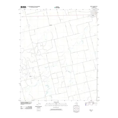
2010 Map of Roby
USGS Topo · Published 2010About this map
Roby stands as the primary hub of activity in this part of Fisher County, organized around a grid of streets at the junction of several regional routes. The surrounding landscape is defined by an extensive network of county roads, such as Co RD 413 and Co RD 417, which service the agricultural and energy interests of the region. The industrial character of the area is highlighted by the Claytonville Oil Field in the southwest, indicating the importance of petroleum extraction to the local economy. Waterways like Cottonwood Creek, East Cottonwood Creek, and Sandy Creek cut through the terrain, providing natural drainage for the subdivided plains. This 2010 survey reflects the enduring rural structure of West Texas, where long-established watercourses and oil production facilities coexist with a precisely surveyed road system.
Find a feature on this map
36 named features on this map. Tap any name to fly to it.
Don’t see what you’re looking for? This feature index may not catch every label — zoom into the map to look around manually.
Map Details
Editions of this 2010 Roby Map
This is the sole edition of this map. No revisions or reprints were ever made.
Other maps of this area

1893 · Roby
USGS Topo · 1:125,000

1931 · Rotan
USGS Topo · 1:62,500

1932 · Camp Springs
USGS Topo · 1:62,500

1954 · Big Spring
USGS Topo · 1:250,000

1958 · Big Spring
USGS Topo · 1:250,000

1969 · Rotan
USGS Topo · 1:24,000

1969 · Busby
USGS Topo · 1:24,000

1969 · Bull Creek
USGS Topo · 1:24,000

1969 · Bernecker
USGS Topo · 1:24,000
1969 · Hobbs
USGS Topo · 1:24,000