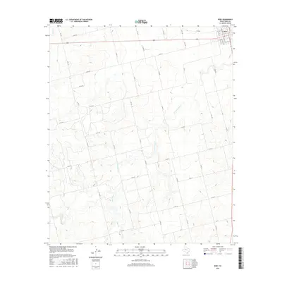
2016 Map of Roby
USGS Topo · Published 2016About this map
The settlement of Roby serves as the focal point for this western Texas landscape, positioned at the intersection of several regional travel routes in the Rolling Plains. The topography is defined by a dense network of intermittent drainages that carve through the dry terrain, including Sandy Creek to the east and the complex system of Cottonwood Creek and East Cottonwood Creek in the central and southern reaches. Small seasonal tributaries like Alkali Creek and Plum Branch highlight the importance of water management in this agricultural environment. The map records a vast grid of county roads, such as Co RD 304 and Co RD 416, which provide access to the dispersed farmsteads and ranch lands surrounding the town center. This layout reflects the enduring rural character of Fisher County, where the street grid of Roby, including West North 3rd Street, transitions abruptly into the broad, sectioned acreage of the surrounding prairie.
Find a feature on this map
50 named features on this map. Tap any name to fly to it.
Don’t see what you’re looking for? This feature index may not catch every label — zoom into the map to look around manually.
Map Details
Editions of this 2016 Roby Map
This is the sole edition of this map. No revisions or reprints were ever made.
Other maps of this area

1893 · Roby
USGS Topo · 1:125,000

1931 · Rotan
USGS Topo · 1:62,500

1932 · Camp Springs
USGS Topo · 1:62,500

1954 · Big Spring
USGS Topo · 1:250,000

1958 · Big Spring
USGS Topo · 1:250,000

1969 · Rotan
USGS Topo · 1:24,000

1969 · Busby
USGS Topo · 1:24,000

1969 · Bull Creek
USGS Topo · 1:24,000

1969 · Bernecker
USGS Topo · 1:24,000
1969 · Hobbs
USGS Topo · 1:24,000