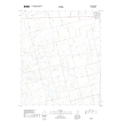
2019 Map of Roby
USGS Topo · Published 2019About this map
Roby serves as the focal point of this West Texas survey, situated at the intersection of several regional travel arteries including US Highway 180 and Fm 419. The town's grid is clearly delineated with local streets like S Lion St and S Concho St framing the central settlement. The surrounding Fisher County landscape is defined by an intricate network of drainage ways and intermittent streams that carve through the terrain, most notably Cottonwood Cr and its tributary Plum Br. To the west and east, the hydrology is further detailed by Alkali Cr and Sandy Cr. This documentation captures the area's transition from the established town center to a vast network of rural roads, such as Co Rd 417 and Co Rd 402, which provide access to the surrounding agricultural and ranch lands characteristic of the region.
Find a feature on this map
50 named features on this map. Tap any name to fly to it.
Don’t see what you’re looking for? This feature index may not catch every label — zoom into the map to look around manually.
Map Details
Editions of this 2019 Roby Map
This is the sole edition of this map. No revisions or reprints were ever made.
Other maps of this area

1893 · Roby
USGS Topo · 1:125,000

1931 · Rotan
USGS Topo · 1:62,500

1932 · Camp Springs
USGS Topo · 1:62,500

1954 · Big Spring
USGS Topo · 1:250,000

1958 · Big Spring
USGS Topo · 1:250,000

1969 · Rotan
USGS Topo · 1:24,000

1969 · Busby
USGS Topo · 1:24,000

1969 · Bull Creek
USGS Topo · 1:24,000

1969 · Bernecker
USGS Topo · 1:24,000
1969 · Hobbs
USGS Topo · 1:24,000