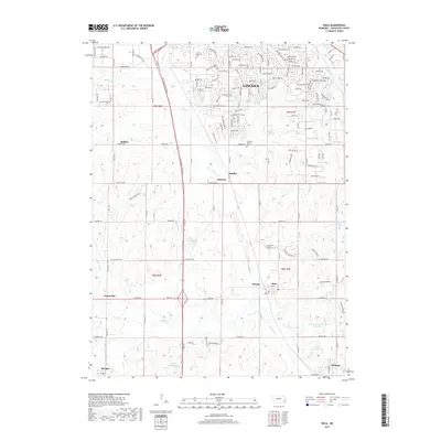
2017 Map of Roca
USGS Topo · Published 2017About this map
Salt Creek defines the drainage of this portion of Lancaster County, following the Salt Valley Roadway south from the expanding outskirts of Lincoln. The landscape transitions from the suburban development of the state capital into a network of smaller rail-stop settlements and agricultural centers. Notable local landmarks include the Simmons - Saltillo Cemetery and the Lincoln Memorial Park, reflecting the long-standing community footprint in the region.
Find a feature on this map
142 named features on this map. Tap any name to fly to it.
Don’t see what you’re looking for? This feature index may not catch every label — zoom into the map to look around manually.
Map Details
Editions of this 2017 Roca Map
This is the sole edition of this map. No revisions or reprints were ever made.
Other maps of this area

1897 · Lincoln
USGS Topo · 1:125,000

1955 · Lincoln
USGS Topo · 1:250,000

1957 · Lincoln
USGS Topo · 1:250,000

1958 · Lincoln
USGS Topo · 1:250,000

1964 · Cortland
USGS Topo · 1:24,000
1964 · Hallam
USGS Topo · 1:24,000

1964 · Denton
USGS Topo · 1:24,000

1964 · Roca
USGS Topo · 1:24,000

1964 · Walton
USGS Topo · 1:24,000
1964 · Emerald
USGS Topo · 1:24,000