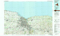
1984 Map of Rochester
USGS Topo · Published 1994About this map
Lake Ontario defines the northern edge of this mid-1980s landscape, where the Genesee River meets the shore at the city of Rochester. The map captures the region's dense academic and medical infrastructure, featuring the Rochester Institute of Technology and the State University of New York at Brockport, alongside several major hospitals including Strong Memorial Hospital. The historic Erie Canal winds through the southern suburbs, passing through Pittsford, Fairport, and Spencerport, illustrating the continued importance of this waterway to the local geography. Along the lakeshore, a series of lagoons and bays like Irondequoit Bay and Braddock Bay create a complex transition between land and water, preserved in part by Hamlin Beach State Park and Durand-Eastman Park. Inland, the terrain is dotted with significant green spaces such as Mendon Ponds Park and Powder Mill Park, showing the area's balance of urban expansion and recreational preservation during this era.
Find a feature on this map
122 named features on this map. Tap any name to fly to it.
Don’t see what you’re looking for? This feature index may not catch every label — zoom into the map to look around manually.
Map Details
Editions of this 1984 Rochester Map
2 editions found
Other maps of this area

1895 · Rochester
USGS Topo · 1:62,500

1895 · Ontario Beach
USGS Topo · 1:62,500

1897 · Albion
USGS Topo · 1:62,500

1897 · Oak Orchard
USGS Topo · 1:62,500

1898 · Rochester
USGS Topo · 1:62,500

1899 · Hamlin
USGS Topo · 1:62,500

1899 · Ontario Beach
USGS Topo · 1:62,500

1899 · Brockport
USGS Topo · 1:62,500

1899 · Palmyra
USGS Topo · 1:62,500

1900 · Macedon
USGS Topo · 1:62,500