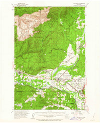
1953 Map of Rochester
USGS Topo · Published 1963About this map
The Chehalis River and its broad valley dominate the southern landscape of this mid-century survey, where river-driven agriculture meets the rising timberlands of the Capitol State Forest. The topography transitions sharply from the alluvial plains of Baker Prairie and Mima Prairie to the high peaks of the Black Hills, including Capitol Peak and Larch Mtn. This area serves as a critical junction for rail transport, with the Northern Pacific and Chicago Milwaukee St Paul and Pacific railroads crisscrossing the lowlands to serve settlements like Rochester and Oakville. Genealogists will find significant detail in the southern portion of the map, which includes the Chehalis Indian Reservation, the State Sch for Girls, and several local landmarks such as the Lincoln Creek Grange and the Historical Marker Fort Henness Site near Grand Mound.
Find a feature on this map
59 named features on this map. Tap any name to fly to it.
Don’t see what you’re looking for? This feature index may not catch every label — zoom into the map to look around manually.
Map Details
Editions of this 1953 Rochester Map
3 editions found

Other maps of this area

1916 · Chehalis
USGS Topo · 1:125,000

1937 · Olympia
USGS Topo · 1:62,500

1939 · Shelton
USGS Topo · 1:62,500

1940 · Tenino
USGS Topo · 1:62,500

1941 · Walville
USGS Topo · 1:62,500

1941 · Meskill
USGS Topo · 1:62,500

1941 · Gate
USGS Topo · 1:62,500

1941 · Ford
USGS Topo · 1:62,500

1943 · Nahwatzel Lake
USGS Topo · 1:62,500

1944 · Tenino
USGS Topo · 1:62,500