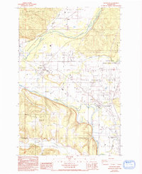
1986 Map of Rochester
USGS Topo · Published 1993About this map
Grand Mound Prairie and several other distinct glacial outwash plains dominate the landscape south of the Black Hills. This 1980s landscape shows the transition from the upland forests of the Capitol State Forest to the broad, flat agricultural and conservation lands along the Black River and Chehalis River. The settlement of Rochester serves as a local hub, surrounded by smaller communities such as Peterson Corner and Mima. A significant historical landmark is the Fort Henness Historical Site located on Grand Mound Prairie. Extensive conservation efforts are evident through the Scatter Creek Wildlife Recreation Area and the Black River Habitat Management Area, which preserve the unique prairie ecosystems. Meanwhile, resource extraction is marked by numerous Gravel Pits and Borrow Pits scattered across the valley floors.
Find a feature on this map
32 named features on this map. Tap any name to fly to it.
Don’t see what you’re looking for? This feature index may not catch every label — zoom into the map to look around manually.
Map Details
Editions of this 1986 Rochester Map
2 editions found
Other maps of this area

1916 · Chehalis
USGS Topo · 1:125,000

1940 · Tenino
USGS Topo · 1:62,500

1941 · Meskill
USGS Topo · 1:62,500

1941 · Gate
USGS Topo · 1:62,500

1944 · Tenino
USGS Topo · 1:62,500

1949 · Tenino
USGS Topo · 1:62,500

1953 · Hoquiam
USGS Topo · 1:250,000

1953 · Rochester
USGS Topo · 1:62,500

1953 · Adna
USGS Topo · 1:62,500

1954 · Centralia
USGS Topo · 1:62,500