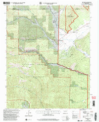
2002 Map of Rociada
USGS Topo · Published 2003About this map
Upper Rociada and the village of Rociada sit at the intersection of high mountain drainage and historical land grants in this 2002 revision. The landscape is defined by the sharp transition from the Pecos Wilderness and Santa Fe National Forest in the west to the managed ranching and resort lands of the Mora Grant and Las Vegas Grant in the east. The Sapello River and its tributaries, including South Sapello River and Manuelitos Creek, carve through the terrain, supporting small settlements and the Pendaries Village community.
Find a feature on this map
36 named features on this map. Tap any name to fly to it.
Don’t see what you’re looking for? This feature index may not catch every label — zoom into the map to look around manually.
Map Details
Editions of this 2002 Rociada Map
This is the sole edition of this map. No revisions or reprints were ever made.
Other maps of this area

1889 · Las Vegas
USGS Topo · 1:125,000

1889 · Santa Fe
USGS Topo · 1:125,000

1891 · Las Vegas
USGS Topo · 1:125,000

1893 · Las Vegas
USGS Topo · 1:125,000

1894 · Santa Fe
USGS Topo · 1:125,000

1954 · Santa Fe
USGS Topo · 1:250,000

1958 · Santa Fe
USGS Topo · 1:250,000

1961 · El Porvenir
USGS Topo · 1:24,000

1961 · Montezuma
USGS Topo · 1:24,000

1961 · Honey Boy Ranch
USGS Topo · 1:24,000