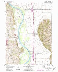
1956 Map of Rock Bluff
USGS Topo · Published 1984About this map
The Missouri River forms the central spine of this 1950s landscape, marking the boundary between Mills and Cass counties and the states of Nebraska and Iowa. The river's dynamic nature is evident in the presence of Tobacco Island, Noddleman Island, and Goose Island, as well as the marshy Slough and various drainage ditches. Small settlements and rural hubs like Rock Bluff, Kenosha, and Sargents Spur anchor the upland and bottomland areas, while local education and burial sites are preserved at the Walnut Grove Sch, Kenosha Sch, and the Rock Bluff Cem. Industry is represented by several extraction sites including Ace Hill Quarry and Tobins Quarry situated near the river bluffs. This period of the mid-20th century shows the established Burlington Northern railroad corridor and conservation efforts at the Scott State Wildlife Management Area.
Find a feature on this map
34 named features on this map. Tap any name to fly to it.
Don’t see what you’re looking for? This feature index may not catch every label — zoom into the map to look around manually.
Map Details
Editions of this 1956 Rock Bluff Map
3 editions found
Other maps of this area

1935 · Nehawka
USGS Topo · 1:48,000

1940 · Nehawka
USGS Topo · 1:62,500

1954 · Omaha
USGS Topo · 1:250,000

1955 · Nebraska City
USGS Topo · 1:250,000

1956 · Glenwood
USGS Topo · 1:24,000

1956 · Murray
USGS Topo · 1:24,000

1956 · Rock Bluff
USGS Topo · 1:24,000

1956 · Plattsmouth
USGS Topo · 1:24,000

1956 · Pacific Junction
USGS Topo · 1:24,000

1957 · Nebraska City
USGS Topo · 1:250,000