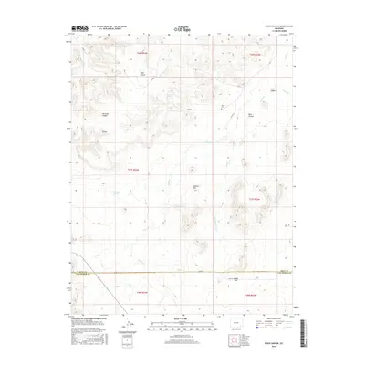
2016 Map of Rock Canyon
USGS Topo · Published 2016About this map
Pruett Cem sits at a crossroads in the northeastern section of this canyon landscape, serving as a rare focal point for local family history in a predominantly open range. The terrain is defined by a dense network of seasonal drainages including Muddy Cr, Antelope Cr, and Johnny Cr, which have carved deep features such as Baker Canyon and Richards Canyon. This high-plains environment is punctuated by Mothers Hill and the distinctive Muddy Gap, located near the border of Bent and Las Animas counties. Water management for cattle or local use is evident through the naming of England Spring and E Parsons Tanks. The map illustrates a sparse but essential road network, including Co RD J and Co RD 90, which connect the isolated canyons and draws of this ranching country.
Find a feature on this map
25 named features on this map. Tap any name to fly to it.
Don’t see what you’re looking for? This feature index may not catch every label — zoom into the map to look around manually.
Map Details
Editions of this 2016 Rock Canyon Map
This is the sole edition of this map. No revisions or reprints were ever made.
Other maps of this area

1891 · Higbee
USGS Topo · 1:125,000

1893 · Higbee
USGS Topo · 1:125,000

1955 · La Junta
USGS Topo · 1:250,000

1958 · La Junta
USGS Topo · 1:250,000
1966 · Toonerville
USGS Topo · 1:24,000
1966 · Turkey Canyon
USGS Topo · 1:24,000
1966 · Higbee
USGS Topo · 1:24,000

1968 · La Junta
USGS Topo · 1:250,000
1971 · Ninaview
USGS Topo · 1:24,000
1971 · Plug Hat Ranch
USGS Topo · 1:24,000