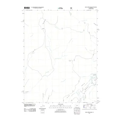
2011 Map of Rock Creek Park
USGS Topo · Published 2011About this map
Rock Creek Cow Camp stands as a focal point of human activity in this high-elevation landscape of Saguache County, Colorado. The terrain is defined by a series of open meadows and basins, including Rock Creek Park, Summit Park, and McDonough Park, which are connected by a complex drainage network. Water management is evident in the southeast at McDonough Reservoir and the associated McDonough Number 1 Dam. The map details numerous named waterways such as School Section Creek, Los Pinos Creek, and Monument Rock Creek, alongside landmarks like East Spring and the curiously named Devils Hole. This 2011 survey documents a remote ranching and grazing environment where named geographic features like Porcupine Park and Pinto Basin reflect a legacy of land use and local navigation through the southern Rocky Mountains.
Find a feature on this map
42 named features on this map. Tap any name to fly to it.
Don’t see what you’re looking for? This feature index may not catch every label — zoom into the map to look around manually.
Map Details
Editions of this 2011 Rock Creek Park Map
This is the sole edition of this map. No revisions or reprints were ever made.
Other maps of this area

1908 · Uncompahgre
USGS Topo · 1:125,000

1911 · Uncompahgre
USGS Topo · 1:125,000

1956 · Montrose
USGS Topo · 1:250,000

1959 · Montrose
USGS Topo · 1:250,000

1960 · Montrose
USGS Topo · 1:250,000

1962 · Rudolph Hill
USGS Topo · 1:24,000

1962 · Powderhorn
USGS Topo · 1:24,000
1962 · Spring Hill Creek
USGS Topo · 1:24,000
1962 · Sawtooth Mountain
USGS Topo · 1:24,000
1963 · Mineral Mountain
USGS Topo · 1:24,000