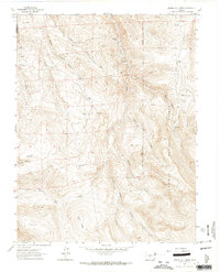
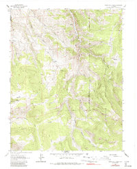
1962 Map of Spring Hill Creek
USGS Topo · Published 1964About this map
Continental Mine and the Midland Mine highlight the mineral extraction history of this mountain landscape along the border of Gunnison and Saguache counties. During the early 1960s, the area remained a working landscape of high-altitude ranching and prospecting, evidenced by the Cooper Ranch, Shelton Ranch, and the remote Mergelmann Cow Camp. The terrain is deeply carved by drainage systems including Spring Hill Creek, South Beaver Creek, and Willow Creek, which flow through the protected boundaries of the Gunnison National Forest. Genealogists and local historians can find traces of early residents at the Watts Homestead near Watts Draw. A network of unimproved roads and a Jeep Trail provide the only access to these isolated sites, linking various unnamed prospects scattered across Black Ridge and the surrounding peaks.
Find a feature on this map
27 named features on this map. Tap any name to fly to it.
Don’t see what you’re looking for? This feature index may not catch every label — zoom into the map to look around manually.
Map Details
Editions of this 1962 Spring Hill Creek Map
5 editions found
Other maps of this area

1908 · Uncompahgre
USGS Topo · 1:125,000

1911 · Uncompahgre
USGS Topo · 1:125,000

1954 · Iris NW
USGS Topo · 1:24,000

1954 · Iola
USGS Topo · 1:24,000

1956 · Montrose
USGS Topo · 1:250,000

1959 · Montrose
USGS Topo · 1:250,000

1960 · Montrose
USGS Topo · 1:250,000

1962 · Rudolph Hill
USGS Topo · 1:24,000

1962 · Iris
USGS Topo · 1:24,000

1962 · Powderhorn
USGS Topo · 1:24,000