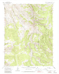
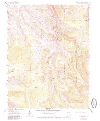
1962 Map of Spring Hill Creek
USGS Topo · Published 1987About this map
Gunnison National Forest dominates the eastern half of this high-country landscape, where the Sawatch Mountains transition into a complex network of ridges and drainage basins. The area serves as a significant intersection of high-altitude ranching and mineral exploration, evidenced by scattered outposts such as Cooper Ranch, Shelton Ranch, and the Midland Ranch. These operations are supported by a seasonal grazing infrastructure that includes the Mergelmann Cow Camp and the Watts Homestead near Watts Draw.
Find a feature on this map
31 named features on this map. Tap any name to fly to it.
Don’t see what you’re looking for? This feature index may not catch every label — zoom into the map to look around manually.
Map Details
Editions of this 1962 Spring Hill Creek Map
5 editions found
Other maps of this area

1908 · Uncompahgre
USGS Topo · 1:125,000

1911 · Uncompahgre
USGS Topo · 1:125,000

1954 · Iris NW
USGS Topo · 1:24,000

1954 · Iola
USGS Topo · 1:24,000

1956 · Montrose
USGS Topo · 1:250,000

1959 · Montrose
USGS Topo · 1:250,000

1960 · Montrose
USGS Topo · 1:250,000

1962 · Rudolph Hill
USGS Topo · 1:24,000

1962 · Iris
USGS Topo · 1:24,000

1962 · Powderhorn
USGS Topo · 1:24,000