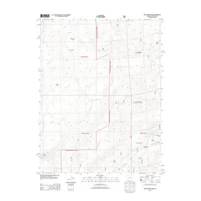
2013 Map of Rock Creek Park
USGS Topo · Published 2013About this map
Gunnison National Forest land defines the high-altitude terrain of this region, where water management and seasonal grazing patterns are etched into the landscape. The Rock Creek Cow Camp provides a specific point of reference for the historical ranching activity that has long utilized these public lands. Centrally, Rock Creek Park and Summit Park occupy the drainages of Rock Cr and Park Cr, which feed into a complex network of named tributaries including N Beaver Cr and Monument Rock Cr.
Find a feature on this map
48 named features on this map. Tap any name to fly to it.
Don’t see what you’re looking for? This feature index may not catch every label — zoom into the map to look around manually.
Map Details
Editions of this 2013 Rock Creek Park Map
This is the sole edition of this map. No revisions or reprints were ever made.
Other maps of this area

1908 · Uncompahgre
USGS Topo · 1:125,000

1911 · Uncompahgre
USGS Topo · 1:125,000

1956 · Montrose
USGS Topo · 1:250,000

1959 · Montrose
USGS Topo · 1:250,000

1960 · Montrose
USGS Topo · 1:250,000

1962 · Rudolph Hill
USGS Topo · 1:24,000

1962 · Powderhorn
USGS Topo · 1:24,000
1962 · Spring Hill Creek
USGS Topo · 1:24,000
1962 · Sawtooth Mountain
USGS Topo · 1:24,000
1963 · Mineral Mountain
USGS Topo · 1:24,000