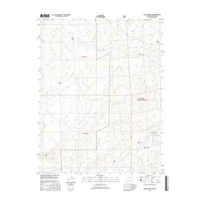
2016 Map of Rock Creek Park
USGS Topo · Published 2016About this map
Rock Creek Park and the surrounding high-altitude basins in the Gunnison National Forest define this 2016 survey of Saguache County. The landscape is a network of named parks and drainage basins, including Summit Park, McDonough Park, and Porcupine Park, which sit between the high ridges. These open meadows are fed by an intricate system of creeks like Monument Rock Cr and N Beaver Cr, punctuated by reliable water sources such as East Spring. The map reveals a land managed for resource and recreation, where Co RD 1 TT provides primary access across the rugged terrain. Notable landmarks such as Devils Hole and the McDonough Reservoir indicate a geography shaped by both natural features and small-scale water management in the Colorado backcountry.
Find a feature on this map
31 named features on this map. Tap any name to fly to it.
Don’t see what you’re looking for? This feature index may not catch every label — zoom into the map to look around manually.
Map Details
Editions of this 2016 Rock Creek Park Map
This is the sole edition of this map. No revisions or reprints were ever made.
Other maps of this area

1908 · Uncompahgre
USGS Topo · 1:125,000

1911 · Uncompahgre
USGS Topo · 1:125,000

1956 · Montrose
USGS Topo · 1:250,000

1959 · Montrose
USGS Topo · 1:250,000

1960 · Montrose
USGS Topo · 1:250,000

1962 · Rudolph Hill
USGS Topo · 1:24,000

1962 · Powderhorn
USGS Topo · 1:24,000
1962 · Spring Hill Creek
USGS Topo · 1:24,000
1962 · Sawtooth Mountain
USGS Topo · 1:24,000
1963 · Mineral Mountain
USGS Topo · 1:24,000