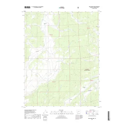
2019 Map of Rock Creek Park
USGS Topo · Published 2019About this map
Rock Creek Park sits at the heart of this high-elevation landscape in Saguache County, where a network of seasonal streams and open parklands characterizes the terrain. The map records several named clearings such as Summit Park, Porcupine Park, and McDonough Park, which are interspersed among the dense wooded boundaries of the Gunnison National Forest. The drainage pattern is particularly intricate here, with Rock Cr and its tributaries, including Monument Rock Cr and School Section Cr, carving through the steep topography. Grounded in the southern reaches, the Pinto Basin offers a distinctive geological landmark, while the presence of East Spring suggests essential water sources in this remote backcountry. The infrastructure is limited primarily to rural routes like Co Rd 17T, reflecting a region dedicated to conservation and natural resource management rather than dense settlement.
Find a feature on this map
25 named features on this map. Tap any name to fly to it.
Don’t see what you’re looking for? This feature index may not catch every label — zoom into the map to look around manually.
Map Details
Editions of this 2019 Rock Creek Park Map
This is the sole edition of this map. No revisions or reprints were ever made.
Other maps of this area

1908 · Uncompahgre
USGS Topo · 1:125,000

1911 · Uncompahgre
USGS Topo · 1:125,000

1956 · Montrose
USGS Topo · 1:250,000

1959 · Montrose
USGS Topo · 1:250,000

1960 · Montrose
USGS Topo · 1:250,000

1962 · Rudolph Hill
USGS Topo · 1:24,000

1962 · Powderhorn
USGS Topo · 1:24,000
1962 · Spring Hill Creek
USGS Topo · 1:24,000
1962 · Sawtooth Mountain
USGS Topo · 1:24,000
1963 · Mineral Mountain
USGS Topo · 1:24,000