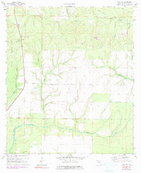
1970 Map of Rock Hill
USGS Topo · Published 1990About this map
Eglin Air Force Base dominates the western edge of this territory, where the landscape transitions from the higher ground of Rock Hill toward the alluvial bottomlands of the Florida Panhandle. The map reveals a dense network of watercourses, including the westward-flowing Lafayette Creek and the meandering Seven Runs, which define the drainage patterns of the region. Local industrial and infrastructure markers such as a Claypit, a Radio Tower, and a Lookout Tower appear alongside the small settlement of Owls Head, providing specific points of interest for those tracing the development of Walton County. The presence of a Landing Strip and the surveying Base Line near Wolf Creek underscore the area's mid-century utility as both a military buffer and a site for resource extraction and land management.
Find a feature on this map
23 named features on this map. Tap any name to fly to it.
Don’t see what you’re looking for? This feature index may not catch every label — zoom into the map to look around manually.
Map Details
Editions of this 1970 Rock Hill Map
3 editions found
Other maps of this area

1935 · De Funiak Springs
USGS Topo · 1:48,000

1936 · Point Washington
USGS Topo · 1:48,000

1938 · De Funiak Springs
USGS Topo · 1:62,500

1939 · Point Washington
USGS Topo · 1:62,500

1944 · Bruce
USGS Topo · 1:24,000

1945 · Bruce
USGS Topo · 1:31,680

1948 · Ponce De Leon
USGS Topo · 1:24,000

1949 · Redbay
USGS Topo · 1:24,000

1950 · Ponce De Leon
USGS Topo · 1:24,000

1950 · Redbay
USGS Topo · 1:24,000