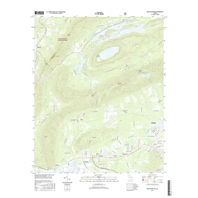
2017 Map of Rock Mountain
USGS Topo · Published 2017About this map
Rock Mountain and Lavender Mtn dominate this portion of the Chattahoochee National Forest, where steep ridges give way to the fertile basins of Big Texas Valley and Little Texas Valley. This landscape is defined by its dramatic topographic relief, including notable gaps like Fouche Gap and Redmond Gap that served as historic corridors through the mountains. The southern portion of the sheet transitions into the more developed outskirts of Rome, centered around the Coosa River and the industry-heavy corridor near Krannert and Oreburg. Local history is preserved in numerous family and community landmarks, from the Cave Spring Cem near Bone to the industrial infrastructure of the Norfolk Southern railroad line. The map captures the complex drainage of the area, where Heath Cr and Smith Cr navigate the narrow valleys between ridges such as Simms Mtn and Turnip Mtn.
Find a feature on this map
108 named features on this map. Tap any name to fly to it.
Don’t see what you’re looking for? This feature index may not catch every label — zoom into the map to look around manually.
Map Details
Editions of this 2017 Rock Mountain Map
This is the sole edition of this map. No revisions or reprints were ever made.
Other maps of this area

1886 · Rome
USGS Topo · 1:125,000

1898 · Rome
USGS Topo · 1:125,000

1899 · Rome
USGS Topo · 1:125,000

1904 · Rome
USGS Topo · 1:125,000

1955 · Rome
USGS Topo · 1:250,000

1958 · Rome
USGS Topo · 1:250,000

1961 · Rome
USGS Topo · 1:250,000

1963 · Rome
USGS Topo · 1:250,000
1966 · Lyerly
USGS Topo · 1:24,000
1967 · Summerville
USGS Topo · 1:24,000