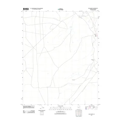
2011 Map of Rock Point
USGS Topo · Published 2011About this map
The Rock Point Trading Post anchors this high-desert landscape in the Shiprock Agency region, serving as a focal point for the small settlement of Rock Point. This early 21st-century survey documents the area's essential infrastructure and natural landmarks, where the network of transportation is defined by routes such as Indian Rte-8090 and Co Rd 491. The topography is characterized by expansive features like the Dibe Chaa Valley and the distinctive formation of Plane Rock, which rise from the arid floor. Water sources are scarce but critical, marked by the presence of Setsiltso Springs in the northern portion of the map. The map details the intersection of local and regional paths, including Indian Rte-8013 and Indian Rte-8014, illustrating how movement in this corner of Arizona is dictated by the terrain's few accessible corridors.
Find a feature on this map
10 named features on this map. Tap any name to fly to it.
Don’t see what you’re looking for? This feature index may not catch every label — zoom into the map to look around manually.
Map Details
Editions of this 2011 Rock Point Map
This is the sole edition of this map. No revisions or reprints were ever made.
Other maps of this area

1892 · Canyon De Chelly
USGS Topo · 1:250,000

1952 · Dinnehotso
USGS Topo · 1:62,500

1952 · Setsiltso Springs 2 SE
USGS Topo · 1:24,000

1954 · Shiprock
USGS Topo · 1:250,000

1958 · Shiprock
USGS Topo · 1:250,000

1959 · Shiprock
USGS Topo · 1:250,000
1968 · Hogansaani Spring
USGS Topo · 1:24,000

1968 · Rock Point SW
USGS Topo · 1:24,000
1968 · Dancing Rocks
USGS Topo · 1:24,000
1968 · White Point
USGS Topo · 1:24,000