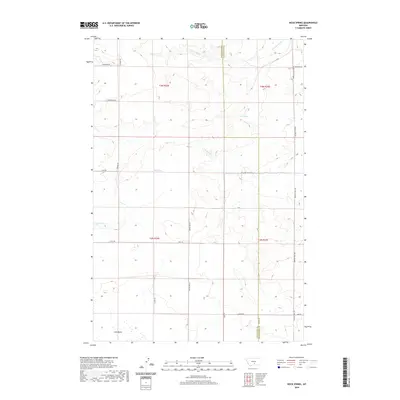
2020 Map of Rock Spring
USGS Topo · Published 2020About this map
Rock Spring and Mud Spring dot this landscape in Yellowstone and Stillwater Counties, marking critical water sources in a region characterized by high plateaus and drainage basins. The southern portion of the map is defined by the broad expanse of Lake Basin, while the northern terrain is dissected by S Comanche Cr and its tributaries. This rural area is knit together by a network of named tracks and thoroughfares, including the evocative Pleasant Valley Trl and Buffalo Trail Rd, which follow the natural contours of the land. The boundary between Stillwater and Yellowstone Counties runs north-south through the center of the sheet, illustrating how jurisdictional lines were often established through these open ranching and agricultural territories. For those researching local land use, the map provides exact locations for water features like Lost Creek and Brown Cr, alongside minor rural routes like Pony Ln and McFarland Rd.
Find a feature on this map
25 named features on this map. Tap any name to fly to it.
Don’t see what you’re looking for? This feature index may not catch every label — zoom into the map to look around manually.
Map Details
Editions of this 2020 Rock Spring Map
This is the sole edition of this map. No revisions or reprints were ever made.
Other maps of this area

1889 · Big Snowy Mountain
USGS Topo · 1:250,000

1892 · Stillwater
USGS Topo · 1:125,000

1893 · Big Snowy Mountain
USGS Topo · 1:250,000

1954 · Billings
USGS Topo · 1:250,000

1954 · Roundup
USGS Topo · 1:250,000

1956 · Comanche
USGS Topo · 1:24,000

1956 · Hunter Lake
USGS Topo · 1:24,000

1956 · Molt
USGS Topo · 1:24,000

1956 · Wheat Basin
USGS Topo · 1:24,000

1956 · Rock Spring
USGS Topo · 1:24,000