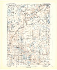
1909 Map of Rockford
USGS Topo · Published 1932About this map
The Crow River winds through this central Minnesota landscape, serving as a natural boundary between Wright and Hennepin counties. During the early twentieth century, the region was defined by small agricultural hubs and milling sites such as Berning Mill. This survey illustrates the early development of the rural road network, with established settlements like St Michael, Hanover, and Rockford positioned along the river's path. Further south, the map details the area around Lake Sarah and Loretto, where the rail lines of the Minneapolis St Paul and Sault Ste Marie Road helped connect these farming communities to larger markets. Notable local institutions, including Salem Church and the Adventist Academy, are clearly marked, providing valuable location data for genealogists and local historians studying the social fabric of the townships of Corcoran and Medina before modern suburban expansion.
Find a feature on this map
79 named features on this map. Tap any name to fly to it.
Don’t see what you’re looking for? This feature index may not catch every label — zoom into the map to look around manually.
Map Details
Editions of this 1909 Rockford Map
2 editions found
Other maps of this area

1896 · Minneapolis
USGS Topo · 1:62,500

1901 · Minneapolis
USGS Topo · 1:62,500

1902 · Anoka
USGS Topo · 1:62,500

1905 · Minnetonka
USGS Topo · 1:62,500

1907 · Minnetonka
USGS Topo · 1:62,500

1909 · Rockford
USGS Topo · 1:62,500

1916 · St. Francis
USGS Topo · 1:62,500

1919 · St. Francis
USGS Topo · 1:62,500

1953 · Saint Paul
USGS Topo · 1:250,000

1953 · Stillwater
USGS Topo · 1:250,000