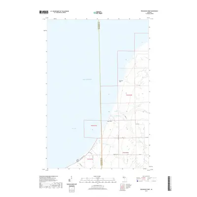
2019 Map of Rockhouse Point
USGS Topo · Published 2019About this map
Lake Superior dominates the western half of this shoreline survey, where the waters of Misery Bay meet the rocky coastline of the Upper Peninsula. The landscape is defined by the drainage systems of the Elm River, S Br Elm River, and Little Elm River, which cut through the terrain toward the lake. Small coastal clearings and seasonal developments like Santa Monica Beach and Agate Beach appear along the waterfront, connected by a network of local roads such as Wolfcreek Acres Rd and Agate Beach Rd. The boundary between Ontonagon and Houghton Counties bisects the area vertically, marking a quiet transition between these timber-rich regions of Northern Michigan. The presence of Rockhouse Point provides a prominent landmark for navigating this stretch of the Keweenaw Peninsula’s western shore.
Find a feature on this map
24 named features on this map. Tap any name to fly to it.
Don’t see what you’re looking for? This feature index may not catch every label — zoom into the map to look around manually.
Map Details
Editions of this 2019 Rockhouse Point Map
This is the sole edition of this map. No revisions or reprints were ever made.
Other maps of this area

1950 · Greenland
USGS Topo · 1:62,500

1951 · Greenland
USGS Topo · 1:62,500

1954 · Graveraet River
USGS Topo · 1:24,000

1954 · Beacon Hill
USGS Topo · 1:24,000

1954 · Rockhouse Point
USGS Topo · 1:24,000

1954 · Winona
USGS Topo · 1:62,500

1958 · Hancock
USGS Topo · 1:250,000

1958 · Iron River
USGS Topo · 1:250,000

1960 · Iron River
USGS Topo · 1:250,000

1960 · Hancock
USGS Topo · 1:250,000