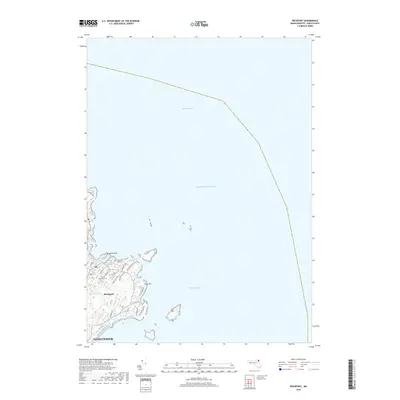
2018 Map of Rockport
USGS Topo · Published 2018About this map
Rockport and the northeastern tip of Cape Ann define this coastal survey, where the rugged granite shoreline meets the Atlantic Ocean. The settlement pattern is concentrated around the harbor and the prominent Bearskin Neck, with a dense network of local streets such as Main St, Pleasant St, and Old Garden Rd extending toward the rocky points. This 2018 data illustrates the modern layout of the maritime community, showing inland water features like Rum Rock Lake and Camborne Pond alongside the expansive Bigelow Bight. Local heritage is anchored by sites such as Beech Grove Cem, while the southern margin reaches the edge of Gloucester. The map captures the specialized geography of this peninsula, from the narrow lanes of Straitsmouth Way to the winding coastal reaches of Eden Rd and Penzance Rd.
Find a feature on this map
29 named features on this map. Tap any name to fly to it.
Don’t see what you’re looking for? This feature index may not catch every label — zoom into the map to look around manually.
Map Details
Editions of this 2018 Rockport Map
This is the sole edition of this map. No revisions or reprints were ever made.
Other maps of this area

1886 · Gloucester
USGS Topo · 1:62,500

1888 · Gloucester
USGS Topo · 1:62,500

1893 · Gloucester
USGS Topo · 1:62,500

1918 · Gloucester
USGS Topo · 1:62,500

1943 · Cape Ann
USGS Topo · 1:125,000
1945 · Rockport
USGS Topo · 1:31,680
1947 · Rockport
USGS Topo · 1:25,000

1948 · Boston
USGS Topo · 1:250,000
1949 · Rockport
USGS Topo · 1:24,000

1956 · Boston
USGS Topo · 1:250,000