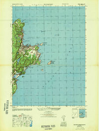
1947 Map of Rockport
USGS Topo · Published 1947About this map
Straitsmouth Lighthouse and the dual beacons of Cape Ann Lighthouse on Thacher Island define this coastal landscape at the edge of the Atlantic Ocean. This post-war Army Map Service survey details the maritime infrastructure of the Cape Ann peninsula, from the protected waters of Sandy Bay to the rocky outcroppings of Dry Salvages. The settlement patterns of Rockport and Pigeon Cove are clearly visible, showing the concentration of homes and industry near the shoreline and along Main St. Inland, the importance of local water sources is noted at Cape Pond, while the coast is dotted with navigational aids and landmarks including Halibut Pt, Gap Head, and the C G Sta at Whale Cove. The map also captures the transition between the developed town center and the recreation-oriented reaches of Long Beach and Brier Neck.
Find a feature on this map
33 named features on this map. Tap any name to fly to it.
Don’t see what you’re looking for? This feature index may not catch every label — zoom into the map to look around manually.
Map Details
Editions of this 1947 Rockport Map
This is the sole edition of this map. No revisions or reprints were ever made.
Other maps of this area

1886 · Gloucester
USGS Topo · 1:62,500

1888 · Gloucester
USGS Topo · 1:62,500

1893 · Gloucester
USGS Topo · 1:62,500

1918 · Gloucester
USGS Topo · 1:62,500

1943 · Cape Ann
USGS Topo · 1:125,000
1945 · Rockport
USGS Topo · 1:31,680

1948 · Boston
USGS Topo · 1:250,000
1949 · Rockport
USGS Topo · 1:24,000

1956 · Boston
USGS Topo · 1:250,000

1958 · Boston
USGS Topo · 1:250,000