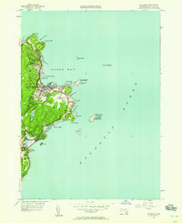
1949 Map of Rockport
USGS Topo · Published 1958About this map
The coastal tip of Cape Ann is defined by the granite-carved harbors of Rockport and Pigeon Cove in this 1949 revision. The landscape reveals a maritime and industrial heritage, with the Boston and Main railroad terminating near the center of town to serve the local economy. Notable landmarks like the Straitsmouth Lighthouse and the twin lights on Thacher Island, including the Cape Ann Lighthouse, guided ships through the treacherous waters of Sandy Bay and around Lands End.
Find a feature on this map
45 named features on this map. Tap any name to fly to it.
Don’t see what you’re looking for? This feature index may not catch every label — zoom into the map to look around manually.
Map Details
Editions of this 1949 Rockport Map
This is the sole edition of this map. No revisions or reprints were ever made.
Other maps of this area

1886 · Gloucester
USGS Topo · 1:62,500

1888 · Gloucester
USGS Topo · 1:62,500

1893 · Gloucester
USGS Topo · 1:62,500

1918 · Gloucester
USGS Topo · 1:62,500

1943 · Cape Ann
USGS Topo · 1:125,000
1945 · Rockport
USGS Topo · 1:31,680
1947 · Rockport
USGS Topo · 1:25,000

1948 · Boston
USGS Topo · 1:250,000

1956 · Boston
USGS Topo · 1:250,000

1958 · Boston
USGS Topo · 1:250,000