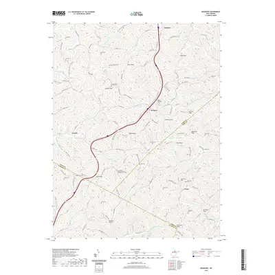
2019 Map of Rockport
USGS Topo · Published 2019About this map
Rockport and its neighboring communities of Lowdell and Saulsbury are situated within a complex landscape of ridges and hollows where Wood, Wirt, and Jackson counties meet. The 2019 data illustrates a rural landscape defined by narrow valley runs and named high points such as Stephens Knob and Bogal Ridge. Genealogists will find a significant concentration of family and community burial grounds, including the Gates Ridge Evangelical United Brethren Church Cemetery and numerous smaller sites like Naylor Cem, Shaffer Cem, and Lott Cem. The Southern Highway and Interstate 77 bisect the area, following the natural corridors formed by Buck Run and Fivemile Run, connecting the disparate ridge settlements. This map provides a detailed view of the modern road network overlaying a traditional Appalachian settlement pattern where churches and cemeteries remain the primary anchors of local history.
Find a feature on this map
140 named features on this map. Tap any name to fly to it.
Don’t see what you’re looking for? This feature index may not catch every label — zoom into the map to look around manually.
Map Details
Editions of this 2019 Rockport Map
This is the sole edition of this map. No revisions or reprints were ever made.
Other maps of this area

1906 · Elizabeth
USGS Topo · 1:62,500

1906 · Belleville
USGS Topo · 1:62,500

1907 · Spencer
USGS Topo · 1:62,500

1907 · Ripley
USGS Topo · 1:62,500

1924 · Belleville
USGS Topo · 1:62,500

1924 · Elizabeth
USGS Topo · 1:62,500

1926 · Elizabeth
USGS Topo · 1:62,500

1926 · Belleville
USGS Topo · 1:62,500

1926 · Ripley
USGS Topo · 1:62,500

1928 · Spencer
USGS Topo · 1:62,500