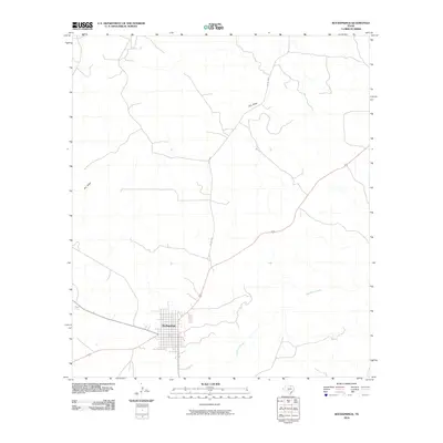
2010 Map of Rocksprings
USGS Topo · Published 2010About this map
Rocksprings serves as the primary hub of this Edwards County landscape, shown here as a structured grid of streets surrounded by the open ranch land of the Edwards Plateau. The town’s location is defined by its position on a high divide, where the drainage patterns move away from the settlement in multiple directions. The intermittent nature of the local hydrology is evident in the presence of Dry Draw to the north and west, while the headwaters of Hackberry Creek emerge to the southeast. These seasonal watercourses dictate the historical placement of ranch roads and cattle movement. A network of rural routes, including Co Rd 2630, radiates from the town center, connecting the remote livestock operations to the county seat in the early 21st century.
Find a feature on this map
4 named features on this map. Tap any name to fly to it.
Don’t see what you’re looking for? This feature index may not catch every label — zoom into the map to look around manually.
Map Details
Editions of this 2010 Rocksprings Map
This is the sole edition of this map. No revisions or reprints were ever made.
Other maps of this area

1893 · Rock Springs
USGS Topo · 1:125,000

1893 · Nueces
USGS Topo · 1:125,000

1896 · Nueces
USGS Topo · 1:125,000

1944 · Indian Creek
USGS Topo · 1:62,500

1947 · Hackberry
USGS Topo · 1:62,500

1954 · Sonora
USGS Topo · 1:250,000

1958 · Sonora
USGS Topo · 1:250,000

1958 · Del Rio
USGS Topo · 1:250,000

1964 · Del Rio
USGS Topo · 1:250,000
1971 · Paint Rock Spring
USGS Topo · 1:24,000