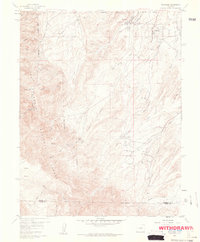
1959 Map of Rockvale
USGS Topo · Published 1961About this map
Rockvale and Coalcreek anchor this industrial landscape during the late 1950s, revealing a region defined by extensive subsurface coal extraction. The eastern half of the map is densely populated with active and inactive workings, from the Coal Creek No 2 Mine to the Black Diamond Mine. An Old Railroad Grade and numerous mine dumps trace the movement of coal from these canyons toward the regional rail hubs. At the Radiant Camp (Site), the transition from active settlement to historical footprint is already evident.
Find a feature on this map
51 named features on this map. Tap any name to fly to it.
Don’t see what you’re looking for? This feature index may not catch every label — zoom into the map to look around manually.
Map Details
Editions of this 1959 Rockvale Map
3 editions found
Other maps of this area

1889 · Canon City
USGS Topo · 1:125,000

1892 · Canon City
USGS Topo · 1:125,000

1954 · Mount Tyndall
USGS Topo · 1:24,000

1954 · Pueblo
USGS Topo · 1:250,000

1957 · Pueblo
USGS Topo · 1:250,000

1958 · Pueblo
USGS Topo · 1:250,000

1959 · Florence
USGS Topo · 1:24,000
1959 · Canon City
USGS Topo · 1:24,000

1959 · Rockvale
USGS Topo · 1:24,000

1959 · Royal Gorge
USGS Topo · 1:62,500