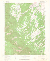
1959 Map of Rockvale
USGS Topo · Published 1964About this map
The industrial coal-mining landscape of southern Colorado is documented in detail on this 1959 survey, particularly around Rockvale and Coalcreek. The northeastern quadrant is densely marked with the legacies of extraction, showing numerous Mine Dumps, the Coal Creek No 2 Mine, and the Filtration Plant essential for local infrastructure. A distinct Old Railroad Grade and the active A T & S F RR line indicate how heavy minerals were moved from sites like the Caldarola No 1 Mine and Twin Pines Mine to the broader market.
Find a feature on this map
52 named features on this map. Tap any name to fly to it.
Don’t see what you’re looking for? This feature index may not catch every label — zoom into the map to look around manually.
Map Details
Editions of this 1959 Rockvale Map
3 editions found
Other maps of this area

1889 · Canon City
USGS Topo · 1:125,000

1892 · Canon City
USGS Topo · 1:125,000

1954 · Mount Tyndall
USGS Topo · 1:24,000

1954 · Pueblo
USGS Topo · 1:250,000

1957 · Pueblo
USGS Topo · 1:250,000

1958 · Pueblo
USGS Topo · 1:250,000

1959 · Florence
USGS Topo · 1:24,000
1959 · Canon City
USGS Topo · 1:24,000

1959 · Rockvale
USGS Topo · 1:24,000

1959 · Royal Gorge
USGS Topo · 1:62,500