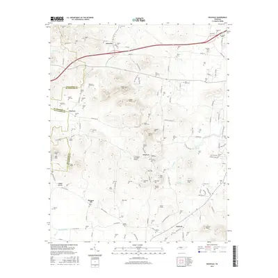
2016 Map of Rockvale
USGS Topo · Published 2016About this map
The boundary between Williamson and Rutherford counties divides this landscape of mid-Tennessee ridges and creek valleys. This modern survey records a deep network of family burial sites, from the Lytlet-Banks and Watson-Rowland cemeteries to the Windrow Church Cem near the settlement of Windrow. These sites, along with others like the Snell-Newman Cem, reveal the genealogical layer of long-established communities such as Almaville and Rockvale.
Find a feature on this map
135 named features on this map. Tap any name to fly to it.
Don’t see what you’re looking for? This feature index may not catch every label — zoom into the map to look around manually.
Map Details
Editions of this 2016 Rockvale Map
This is the sole edition of this map. No revisions or reprints were ever made.
Other maps of this area

1916 · Murfreesboro
USGS Topo · 1:62,500

1936 · Chapel Hill
USGS Topo · 1:24,000

1936 · Rover
USGS Topo · 1:24,000

1936 · Fosterville
USGS Topo · 1:24,000

1942 · Lebanon
USGS Topo · 1:100,000

1944 · Shelbyville
USGS Topo · 1:100,000
1949 · Rover
USGS Topo · 1:24,000
1949 · Chapel Hill
USGS Topo · 1:24,000
1949 · Fosterville
USGS Topo · 1:24,000

1950 · Walterhill
USGS Topo · 1:24,000