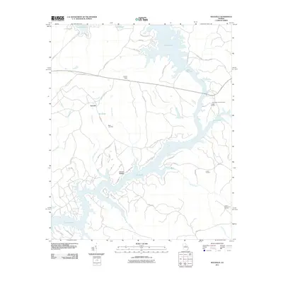
2011 Map of Rockville
USGS Topo · Published 2011About this map
Lake Sinclair and Lake Oconee dominate this landscape in Putnam County, where the impounded waters of the Oconee River create a complex shoreline of inlets and points. The settlement of Rockville sits inland, connected by Texas Chapel Rd and marked by the Rockville Lookout Tower, while Oconee Springs serves as a focal point along the southern lakefront. The map reveals a transition from traditional upland settlements to a contemporary landscape shaped by recreation and water management, evidenced by the Rockville Springs Lndg. Genealogists will find several burial sites preserved amidst the modern development, including the Little-Hudson Family Cemetery and the Clayton-Bonner Family Cemetery. The local drainage pattern is defined by several tributaries like Log Dam Creek and Cattall Branch, which feed into the primary reservoirs.
Find a feature on this map
60 named features on this map. Tap any name to fly to it.
Don’t see what you’re looking for? This feature index may not catch every label — zoom into the map to look around manually.
Map Details
Editions of this 2011 Rockville Map
This is the sole edition of this map. No revisions or reprints were ever made.
Other maps of this area

1912 · Milledgeville
USGS Topo · 1:62,500

1953 · Athens
USGS Topo · 1:250,000

1958 · Athens
USGS Topo · 1:250,000

1959 · Athens
USGS Topo · 1:250,000

1963 · Athens
USGS Topo · 1:250,000

1972 · Liberty
USGS Topo · 1:24,000

1972 · Shoulderbone
USGS Topo · 1:24,000

1972 · Meda
USGS Topo · 1:24,000

1972 · Harmony
USGS Topo · 1:24,000
1972 · Devereux
USGS Topo · 1:24,000