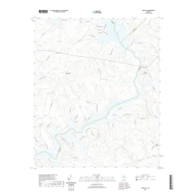
2020 Map of Rockville
USGS Topo · Published 2020About this map
The waters of Lake Oconee and Lake Sinclair dominate this portion of the Piedmont, where the borders of Putnam, Greene, and Hancock counties converge. The small settlement of Rockville sits as a central inland hub, surrounded by a complex network of creeks and branches including Rush Cr, Cattail Br, and Herndon Br. This modern survey reveals how local infrastructure has adapted to the jagged shorelines created by these reservoirs, with residential developments like those along Lake Crest Dr and Shagbark Point Dr appearing alongside older rural landscapes. Genealogists and local historians will find value in the preservation of small, family-owned burial grounds that persist amidst the newer subdivisions and shoreline properties. Notable landmarks such as Grabel Shoals and Basil Lake provide further context to the hydrological character of the area, while the naming of Log Dam Cr hints at earlier industrial or timber practices along the local waterways.
Find a feature on this map
62 named features on this map. Tap any name to fly to it.
Don’t see what you’re looking for? This feature index may not catch every label — zoom into the map to look around manually.
Map Details
Editions of this 2020 Rockville Map
This is the sole edition of this map. No revisions or reprints were ever made.
Other maps of this area

1912 · Milledgeville
USGS Topo · 1:62,500

1953 · Athens
USGS Topo · 1:250,000

1958 · Athens
USGS Topo · 1:250,000

1959 · Athens
USGS Topo · 1:250,000

1963 · Athens
USGS Topo · 1:250,000

1972 · Liberty
USGS Topo · 1:24,000

1972 · Shoulderbone
USGS Topo · 1:24,000

1972 · Meda
USGS Topo · 1:24,000

1972 · Harmony
USGS Topo · 1:24,000
1972 · Devereux
USGS Topo · 1:24,000