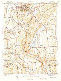
1944 Map of Rockville
USGS Topo · Published 1944About this map
Rockville stands as a dense industrial and residential hub at the northern edge of this wartime survey, centered near the steep rise of Fox Hill. The landscape transitions south through the hills of Vernon and Bolton, where the New York New Haven And Hartford railroad snakes through the significant geological pass at Bolton Notch. The map reveals a high concentration of institutional and community landmarks, from the County Home and Maple St Sch to several outlying rural schoolhouses that served the scattered settlements of North Coventry and Highland Park.
Find a feature on this map
60 named features on this map. Tap any name to fly to it.
Don’t see what you’re looking for? This feature index may not catch every label — zoom into the map to look around manually.
Map Details
Editions of this 1944 Rockville Map
4 editions found
Other maps of this area

1892 · Hartford
USGS Topo · 1:62,500

1892 · Tolland
USGS Topo · 1:62,500

1892 · Gilead
USGS Topo · 1:62,500

1893 · Middletown
USGS Topo · 1:62,500

1906 · Farmington
USGS Topo · 1:125,000

1921 · Tolland
USGS Topo · 1:62,500

1928 · Glastonbury
USGS Topo · 1:24,000

1928 · Broad Brook
USGS Topo · 1:24,000

1928 · Manchester
USGS Topo · 1:24,000

1944 · Manchester
USGS Topo · 1:31,680