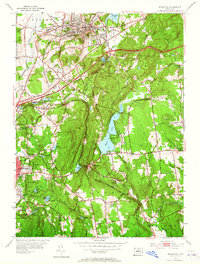
1953 Map of Rockville
USGS Topo · Published 1965About this map
Rockville stands as a significant industrial and population center in the mid-1950s, its urban grid tightly packed between Fox Hill and the shores of Shenipsit Lake. This mid-century landscape is defined by the intersection of traditional rail transport and modern high-speed thoroughfares. The New York New Haven and Hartford RR winds through the topography, serving established mill settlements like Talcottville and Lydallville, while the prominent Wilbur Cross Highway cuts across the terrain, signaling the post-war shift toward automobile-centric development.
Find a feature on this map
65 named features on this map. Tap any name to fly to it.
Don’t see what you’re looking for? This feature index may not catch every label — zoom into the map to look around manually.
Map Details
Editions of this 1953 Rockville Map
3 editions found
Other maps of this area

1892 · Hartford
USGS Topo · 1:62,500

1892 · Tolland
USGS Topo · 1:62,500

1892 · Gilead
USGS Topo · 1:62,500

1893 · Middletown
USGS Topo · 1:62,500

1906 · Farmington
USGS Topo · 1:125,000

1921 · Tolland
USGS Topo · 1:62,500

1928 · Glastonbury
USGS Topo · 1:24,000

1928 · Broad Brook
USGS Topo · 1:24,000

1928 · Manchester
USGS Topo · 1:24,000

1944 · Manchester
USGS Topo · 1:31,680