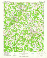
1962 Map of Rockwell
USGS Topo · Published 1964About this map
Granite Quarry and the nearby town of Faith center a landscape defined by industry and deep-rooted community institutions in the early 1960s. The map illustrates a high density of stone extraction sites, with numerous Quarries and Granite Lake marking the terrain around Litaker and Gold Hill. This industrial character is balanced by a rich collection of historic religious and social landmarks, including the notable Old Stone House and several significant houses of worship like Organ Ch and Grace-Lower Stone Ch.
Find a feature on this map
66 named features on this map. Tap any name to fly to it.
Don’t see what you’re looking for? This feature index may not catch every label — zoom into the map to look around manually.
Map Details
Editions of this 1962 Rockwell Map
3 editions found
Other maps of this area

1893 · Statesville
USGS Topo · 1:125,000

1941 · Charlotte
USGS Topo · 1:125,000

1942 · Charlotte
USGS Topo · 1:125,000

1950 · Concord
USGS Topo · 1:24,000

1953 · Charlotte
USGS Topo · 1:250,000

1954 · Charlotte
USGS Topo · 1:250,000

1957 · Mount Pleasant
USGS Topo · 1:62,500

1960 · Charlotte
USGS Topo · 1:250,000

1962 · Charlotte
USGS Topo · 1:250,000

1962 · Southmont
USGS Topo · 1:24,000