1952 Map of Rockwood
USGS Topo · Published 1954About this map
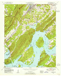
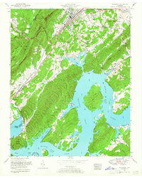
Rockwood sits at the foot of the Cumberland Escarpment, where the high plateau of Mt Roosevelt drops toward the Tennessee River valley. This 1952 revision captures the region after the creation of Watts Bar Lake, illustrating how the rising waters transformed the lower reaches of King Creek and Whites Creek into broad, navigable bays. The map documents a deeply established rural community, visible through an extensive network of country landmarks like the Odd Fellows Cemetery, Pond Grove School, and Luminary Church. Near the lake's edge, industrial and social sites such as Eagle Furnace and the Eagle Point Cabin Area show the evolving economy of the shoreline. Transportation is anchored by the Southern railroad and the Walton Road, which historically served as a vital passage through these ridges.
Find a feature on this map
88 named features on this map. Tap any name to fly to it.
Don’t see what you’re looking for? This feature index may not catch every label — zoom into the map to look around manually.
Map Details
Editions of this 1952 Rockwood Map
2 editions found
Other maps of this area

1887 · Kingston
USGS Topo · 1:125,000

1891 · Kingston
USGS Topo · 1:125,000

1893 · Kingston
USGS Topo · 1:125,000

1935 · Rockwood
USGS Topo · 1:24,000
1935 · Harriman
USGS Topo · 1:24,000

1936 · Roddy
USGS Topo · 1:24,000

1936 · Ozone
USGS Topo · 1:24,000

1936 · Cardiff
USGS Topo · 1:24,000
1936 · Spring City
USGS Topo · 1:24,000

1936 · Pattie Gap
USGS Topo · 1:24,000