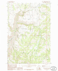
1986 Map of Rocky Comfort Flat
USGS Topo · Published 1986About this map
The Cuddy Mountains dominate this 1980s landscape within the Payette National Forest, where steep drainages and high flats define the topography of Adams County. The terrain is marked by distinctive level areas such as Rocky Comfort Flat and Paradise Flat, providing a sharp contrast to the surrounding ridges. Water is a defining force on this sheet, featuring the Bear Creek Falls and the junction of numerous watercourses including the Wildhorse River, Crooked River, and Lick Creek. Evidence of resource exploration and small-scale infrastructure is present through several prospects and a remote Landing Strip near the river. This survey captures a moment when the wilderness was managed for multiple uses, balancing natural landmarks like Clifton Spring and Cows Spring with the practical needs of forest access and navigation.
Find a feature on this map
33 named features on this map. Tap any name to fly to it.
Don’t see what you’re looking for? This feature index may not catch every label — zoom into the map to look around manually.
Map Details
Editions of this 1986 Rocky Comfort Flat Map
This is the sole edition of this map. No revisions or reprints were ever made.
Other maps of this area

1920 · Seven Devils Mining District
USGS Topo · 1:48,000

1955 · Baker
USGS Topo · 1:250,000

1955 · Grangeville
USGS Topo · 1:250,000

1957 · Cuprum
USGS Topo · 1:62,500

1957 · Homestead
USGS Topo · 1:62,500

1957 · Copperfield
USGS Topo · 1:62,500

1957 · Hornet
USGS Topo · 1:62,500

1959 · Baker
USGS Topo · 1:250,000

1959 · Grangeville
USGS Topo · 1:250,000

1980 · McCall
USGS Topo · 1:100,000