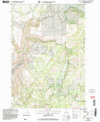
2004 Map of Rocky Comfort Flat
USGS Topo · Published 2007About this map
Payette National Forest dominates this Idaho landscape, where the Cuddy Mountains rise sharply above the Wildhorse River. The area is defined by its high-altitude flats, notably Rocky Comfort Flat and Paradise Flat, which suggest a history of seasonal grazing or upland travel in the backcountry. A primitive Landing Strip near the center of the sheet indicates the logistical challenges of reaching this remote interior terrain. For those tracing the human footprint of the early 2000s, the map reveals isolated settlements like Warner and Comfort, alongside signs of resource exploration at Prospects and an Adit near Summit Creek. The hydrological network is dense, featuring landmarks like Bear Creek Falls and the managed infrastructure of Cottonwood Corrals, reflecting a landscape shared by wilderness and ranching interests.
Find a feature on this map
55 named features on this map. Tap any name to fly to it.
Don’t see what you’re looking for? This feature index may not catch every label — zoom into the map to look around manually.
Map Details
Editions of this 2004 Rocky Comfort Flat Map
This is the sole edition of this map. No revisions or reprints were ever made.
Other maps of this area

1920 · Seven Devils Mining District
USGS Topo · 1:48,000

1955 · Baker
USGS Topo · 1:250,000

1955 · Grangeville
USGS Topo · 1:250,000

1957 · Cuprum
USGS Topo · 1:62,500

1957 · Homestead
USGS Topo · 1:62,500

1957 · Copperfield
USGS Topo · 1:62,500

1957 · Hornet
USGS Topo · 1:62,500

1959 · Baker
USGS Topo · 1:250,000

1959 · Grangeville
USGS Topo · 1:250,000

1980 · McCall
USGS Topo · 1:100,000