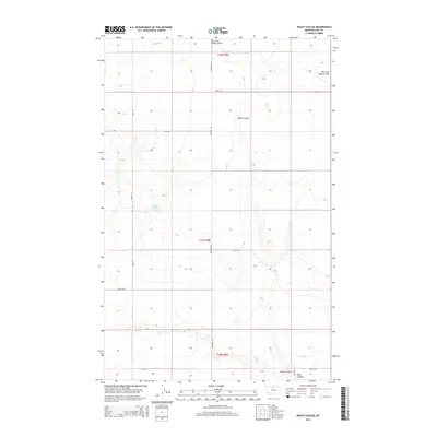
2014 Map of Rocky Coulee
USGS Topo · Published 2014About this map
Cockerel Spring serves as a vital water source in this high plains landscape of Hill County, where the terrain is defined by the deep drainage patterns of the Rocky Coulee and the East Fork Black Coulee. Surveyed in 2014, the map reveals a systematic grid of section lines and gravel roads, including Inverness Rd and Road 50 S, which facilitate the region's agricultural and ranching activities. This layout reflects the enduring influence of the Public Land Survey System on Montana’s rural development, showing how infrastructure follows the natural contours of the land. The proximity of Black Coulee to the southern edge suggests a connectivity between these local watersheds and the broader regional topography, providing an essential resource for those researching the land use and hydrology of the northern plains.
Find a feature on this map
15 named features on this map. Tap any name to fly to it.
Don’t see what you’re looking for? This feature index may not catch every label — zoom into the map to look around manually.
Map Details
Editions of this 2014 Rocky Coulee Map
This is the sole edition of this map. No revisions or reprints were ever made.
Other maps of this area

1919 · Alma
USGS Topo · 1:125,000

1954 · Shelby
USGS Topo · 1:250,000

1958 · Shelby
USGS Topo · 1:250,000

1963 · Joplin
USGS Topo · 1:24,000

1970 · Poverty Coulee NE
USGS Topo · 1:24,000
1970 · Rocky Coulee SE
USGS Topo · 1:24,000

1970 · Poverty Coulee SE
USGS Topo · 1:24,000

1970 · Rocky Coulee SW
USGS Topo · 1:24,000

1970 · Rocky Coulee
USGS Topo · 1:24,000
1970 · Een School
USGS Topo · 1:24,000