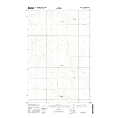
2017 Map of Rocky Coulee
USGS Topo · Published 2017About this map
Cockerel Spring serves as a vital water source in this section of Hill County, where the high plains are carved by a network of seasonal drainages. The landscape is defined by its coulees, with Rocky Coulee and Black Coulee providing significant topographic relief against the surrounding agricultural or grazing land. A structured grid of section lines and gravel routes, such as Inverness Rd S and Rd 15 S, dictates the movement across the terrain, reflecting the long-standing Public Land Survey System divisions in Montana. The presence of the East Fork Black Coulee and Flat Coulee further illustrates the complex watershed patterns that dictate land use in this northern prairie environment.
Find a feature on this map
12 named features on this map. Tap any name to fly to it.
Don’t see what you’re looking for? This feature index may not catch every label — zoom into the map to look around manually.
Map Details
Editions of this 2017 Rocky Coulee Map
This is the sole edition of this map. No revisions or reprints were ever made.
Other maps of this area

1919 · Alma
USGS Topo · 1:125,000

1954 · Shelby
USGS Topo · 1:250,000

1958 · Shelby
USGS Topo · 1:250,000

1963 · Joplin
USGS Topo · 1:24,000

1970 · Poverty Coulee NE
USGS Topo · 1:24,000
1970 · Rocky Coulee SE
USGS Topo · 1:24,000

1970 · Poverty Coulee SE
USGS Topo · 1:24,000

1970 · Rocky Coulee SW
USGS Topo · 1:24,000

1970 · Rocky Coulee
USGS Topo · 1:24,000
1970 · Een School
USGS Topo · 1:24,000