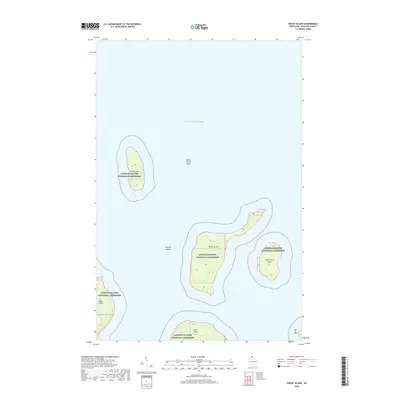
2018 Map of Rocky Island
USGS Topo · Published 2018About this map
Devils Island and its surrounding waters define the northern reaches of this maritime landscape within the Apostle Islands National Lakeshore. Situated in Lake Superior, this remote archipelago is documented with precision, showing the isolated landmasses of Rocky Island, South Twin Island, Bear Island, and Otter Island. The map illustrates the bathymetry and shoreline characteristics that define the northern tip of Wisconsin, including the submerged hazards of Devils Island Shoal. This modern survey by the U.S. Geological Survey captures the protected geography of the islands as they exist today, serving as a detailed record of the natural boundaries and landforms that constitute this unique national treasure. The absence of traditional road networks emphasizes the wilderness character of the islands, where navigation is dictated by the water and the rugged coastal edges of the Apostle Islands.
Find a feature on this map
10 named features on this map. Tap any name to fly to it.
Don’t see what you’re looking for? This feature index may not catch every label — zoom into the map to look around manually.
Map Details
Editions of this 2018 Rocky Island Map
This is the sole edition of this map. No revisions or reprints were ever made.
Other maps of this area

1941 · Bayfield
USGS Topo · 1:48,000

1946 · Bayfield
USGS Topo · 1:48,000

1953 · Ashland
USGS Topo · 1:250,000

1954 · Two Harbors
USGS Topo · 1:250,000

1957 · Two Harbors
USGS Topo · 1:250,000

1958 · Ashland
USGS Topo · 1:250,000

1958 · Two Harbors
USGS Topo · 1:250,000

1963 · Cat Island
USGS Topo · 1:24,000

1963 · Rocky Island
USGS Topo · 1:62,500

1963 · Oak Island
USGS Topo · 1:24,000