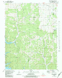
1983 Map of Rocky Mount
USGS Topo · Published 1983About this map
The Morgan and Miller County line divides this landscape, where the rugged drainages of the Ozark plateau meet the regulated waters of the Lake of the Ozarks. Established family names are preserved through numerous burial grounds such as Sidebottom Cem, Cooper Cem, and Riley Lamb Cem, indicating long-standing rural settlement patterns. The topography is defined by deep hollows like Shelton Hollow and Louis Woods Hollow that channel water toward the Gravois Arm. This 1983 edition shows the area's mixed economy, from the extractive history of the Stover Mine to the modern conservation efforts at the Rocky Mount Towersite State Wildlife Area. Local social life centers on small congregations including Union Ch and Rocky Mount Ch, while the St Louis Southwestern corridor cuts across the northern reaches near Barnett.
Find a feature on this map
52 named features on this map. Tap any name to fly to it.
Don’t see what you’re looking for? This feature index may not catch every label — zoom into the map to look around manually.
Map Details
Editions of this 1983 Rocky Mount Map
This is the sole edition of this map. No revisions or reprints were ever made.
Other maps of this area

1888 · Versailles
USGS Topo · 1:125,000

1893 · Versailles
USGS Topo · 1:125,000

1904 · Eldon
USGS Topo · 1:62,500

1904 · Gravois Mills
USGS Topo · 1:62,500

1932 · Versailles No 4
USGS Topo · 1:48,000

1934 · Purvis
USGS Topo · 1:24,000

1934 · Lake Ozark
USGS Topo · 1:24,000

1934 · Bagnell
USGS Topo · 1:24,000

1935 · Gravois Mills
USGS Topo · 1:24,000

1935 · Rocky Mount
USGS Topo · 1:24,000