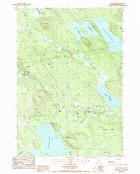
1987 Map of Rocky Pond
USGS Topo · Published 1988About this map
The Union River watershed dominates this part of Hancock County, characterized by an extensive network of ponds and glacial ridges in the late 1980s. The landscape is defined by its water bodies, from the sprawling Rocky Pond and Spectacle Pond in the south to the chain of Upper Lead Mtn Pond, Middle Lead Mtn Pond, and Lower Lead Mtn Pond in the north. Settlement is sparse, with small crossroads like Dog Corners providing the few points of human activity amidst the wooded terrain of Aurora and Osborn.
Find a feature on this map
40 named features on this map. Tap any name to fly to it.
Don’t see what you’re looking for? This feature index may not catch every label — zoom into the map to look around manually.
Map Details
Editions of this 1987 Rocky Pond Map
This is the sole edition of this map. No revisions or reprints were ever made.
Other maps of this area

1911 · Ellsworth
USGS Topo · 1:62,500

1929 · Great Pond
USGS Topo · 1:48,000

1929 · Lead Mountain
USGS Topo · 1:48,000

1930 · Tunk Lake
USGS Topo · 1:48,000

1932 · Tunk Lake
USGS Topo · 1:62,500

1932 · Lead Mountain
USGS Topo · 1:62,500

1932 · Great Pond
USGS Topo · 1:62,500

1940 · Ellsworth
USGS Topo · 1:62,500

1942 · Ellsworth
USGS Topo · 1:62,500

1942 · Tunk Lake
USGS Topo · 1:62,500
Featured Places
- Aurora, ME
- Osborn, ME
- T22 MD BPP Township, ME
- T16 MD BPP Township, ME
- Steep Landing, T22 MD BPP Township