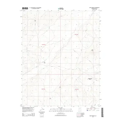
2014 Map of Rocky Ridge SE
USGS Topo · Published 2014About this map
Rocky Ridge anchors this landscape in the northern Navajo Nation, where the high desert terrain of the Third Mesa plateau defines the local geography. Small, traditionally named settlements like Toh Honi Ni Toh and Toh Ah Honnie Betoh appear along the base of the Cliff Rdg, reflecting the sparse but enduring residential patterns of the Chinle Agency. A network of Bureau of Indian Affairs roads, including Bia-6610 and Bia-6621, connect these communities to essential landmarks like the Navajo Gospel Mission and the Rocky Ridge Airport. To the east, Many Bobcats Hill rises above the plains near Route 22, while the drainage of the Oraibi Wash marks the southeastern corner, illustrating the vital role of intermittent water sources in this arid environment.
Find a feature on this map
24 named features on this map. Tap any name to fly to it.
Don’t see what you’re looking for? This feature index may not catch every label — zoom into the map to look around manually.
Map Details
Editions of this 2014 Rocky Ridge SE Map
This is the sole edition of this map. No revisions or reprints were ever made.
Other maps of this area

1883 · Marsh Pass
USGS Topo · 1:250,000

1883 · Tusayan
USGS Topo · 1:250,000

1886 · Tusayan
USGS Topo · 1:250,000

1892 · Marsh Pass
USGS Topo · 1:250,000

1947 · Flagstaff
USGS Topo · 1:250,000

1954 · Flagstaff
USGS Topo · 1:250,000

1956 · Marble Canyon
USGS Topo · 1:250,000

1958 · Flagstaff
USGS Topo · 1:250,000

1959 · Marble Canyon
USGS Topo · 1:250,000

1960 · Flagstaff
USGS Topo · 1:250,000