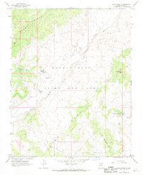
1967 Map of Rocky Ridge Se
USGS Topo · Published 1969About this map
Third Mesa and the expansive drainage of Dinnebito Wash define the topography of this high-desert landscape in the late 1960s. The map captures a unique administrative moment, illustrating the boundaries of the Navajo Hopi Joint Use Area alongside the Hopi Indian Reservation. Evidence of community life is centered at the Navajo Gospel Mission, which sits near a small Cem and local landmarks like Cha Ni Betoh.
Find a feature on this map
19 named features on this map. Tap any name to fly to it.
Don’t see what you’re looking for? This feature index may not catch every label — zoom into the map to look around manually.
Map Details
Editions of this 1967 Rocky Ridge Se Map
This is the sole edition of this map. No revisions or reprints were ever made.
Other maps of this area

1883 · Marsh Pass
USGS Topo · 1:250,000

1883 · Tusayan
USGS Topo · 1:250,000

1886 · Tusayan
USGS Topo · 1:250,000

1892 · Marsh Pass
USGS Topo · 1:250,000

1947 · Flagstaff
USGS Topo · 1:250,000

1954 · Flagstaff
USGS Topo · 1:250,000

1956 · Marble Canyon
USGS Topo · 1:250,000

1958 · Flagstaff
USGS Topo · 1:250,000

1959 · Marble Canyon
USGS Topo · 1:250,000

1960 · Flagstaff
USGS Topo · 1:250,000