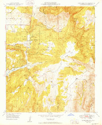
1949 Map of Rodriguez Mtn.
USGS Topo · Published 1949About this map
The Rincon Indian Reservation and San Pasqual Indian Reservation define much of this interior San Diego County landscape at the close of the 1940s. Centered around Rodriguez Mountain, the map captures a rural transition where ranching and early irrigation efforts shape the terrain. Notable local centers of activity include the Melrose Ranch and Vineyard Ranch, alongside the Bear Valley School. These sites, connected by winding routes like Woods Valley Road, reflect a period of decentralized settlement before modern suburban expansion.
Find a feature on this map
38 named features on this map. Tap any name to fly to it.
Don’t see what you’re looking for? This feature index may not catch every label — zoom into the map to look around manually.
Map Details
Editions of this 1949 Rodriguez Mtn. Map
2 editions found
Other maps of this area

1893 · Escondido
USGS Topo · 1:62,500

1901 · Escondido
USGS Topo · 1:62,500

1901 · San Luis Rey
USGS Topo · 1:125,000

1903 · Ramona
USGS Topo · 1:125,000

1904 · Southern California Sheet No. 2
USGS Topo · 1:250,000

1939 · Palomar Mountain
USGS Topo · 1:62,500

1942 · Temecula
USGS Topo · 1:62,500

1942 · Escondido
USGS Topo · 1:62,500

1942 · Ramona
USGS Topo · 1:62,500

1947 · Ramona
USGS Topo · 1:62,500