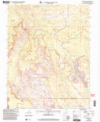
2002 Map of Roger Peak
USGS Topo · Published 2005About this map
Roger Peak rises as a primary landmark in this high-elevation corner of Garfield County, where the topography is defined by the transitions between the Dixie National Forest and the Box Death Hollow Wilderness. The landscape is a network of deep drainages and flat-topped mesas, such as King Bench and Saddle Bench, which guide the flow of Sweetwater Creek and Sand Creek. Cultural footprints in this remote area are sparse but significant, centered on the King Ranch and various Corral sites that suggest a long-standing ranching presence near Salt Gulch.
Find a feature on this map
41 named features on this map. Tap any name to fly to it.
Don’t see what you’re looking for? This feature index may not catch every label — zoom into the map to look around manually.
Map Details
Editions of this 2002 Roger Peak Map
This is the sole edition of this map. No revisions or reprints were ever made.
Other maps of this area

1885 · Fish Lake
USGS Topo · 1:250,000

1886 · Escalante
USGS Topo · 1:250,000

1896 · Fish Lake
USGS Topo · 1:250,000

1952 · Notom 3 SW
USGS Topo · 1:24,000

1952 · Grover
USGS Topo · 1:62,500

1956 · Escalante
USGS Topo · 1:250,000

1956 · Salina
USGS Topo · 1:250,000

1960 · Escalante
USGS Topo · 1:250,000

1960 · Salina
USGS Topo · 1:250,000

1962 · Salina
USGS Topo · 1:250,000