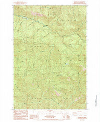
1984 Map of Rogers Peak
USGS Topo · Published 1984About this map
Tillamook State Forest covers this landscape in the mid-1980s, where the winding Salmonberry River and Wilson River carve through the coastal range. The industrial legacy of the region is traced through the Southern Pacific railroad line, which navigates steep terrain via a series of tunnels near the Enright (Site) and Belfort locations. These points, along with Belding, represent the scattered settlements and railway stops tied to the timber economy and rugged topography of the area.
Find a feature on this map
33 named features on this map. Tap any name to fly to it.
Don’t see what you’re looking for? This feature index may not catch every label — zoom into the map to look around manually.
Map Details
Editions of this 1984 Rogers Peak Map
This is the sole edition of this map. No revisions or reprints were ever made.
Other maps of this area

1937 · Enright
USGS Topo · 1:62,500

1939 · Saddle Mountain
USGS Topo · 1:62,500

1941 · Keasey
USGS Topo · 1:62,500

1941 · Timber
USGS Topo · 1:62,500

1941 · Enright
USGS Topo · 1:62,500

1943 · Keasey
USGS Topo · 1:62,500

1943 · Saddle Mtn.
USGS Topo · 1:62,500

1948 · Vancouver
USGS Topo · 1:250,000

1950 · Vancouver
USGS Topo · 1:250,000

1950 · Vancouver
USGS Topo · 1:250,000