
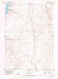
1977 Map of Rogerson
USGS Topo · Published 1978About this map
The high desert community of Rogerson serves as a focal point in this south-central Idaho survey, where the Union Pacific railroad corridor and Jarbidge Road intersect. This area is defined by its livestock history and water management, visible through the presence of the Deep Creek Meadows Ranch and Duck Springs Ranch. The landscape is etched by drainage networks like Deep Creek, Soldier Creek, and Cottonwood Creek, which are supplemented by vital water sources such as Rogerson Spring and Dan Spring. Local infrastructure of the era is marked by several water tanks and a network of jeep trails, including the Magic Hot Springs Road. Significant local landmarks include the Cem south of town and the distinctive high point known as Flatiron.
Find a feature on this map
21 named features on this map. Tap any name to fly to it.
Don’t see what you’re looking for? This feature index may not catch every label — zoom into the map to look around manually.
Map Details
Editions of this 1977 Rogerson Map
This is the sole edition of this map. No revisions or reprints were ever made.
Other maps of this area

1955 · Twin Falls
USGS Topo · 1:250,000

1958 · Twin Falls
USGS Topo · 1:250,000

1965 · Hollister SW
USGS Topo · 1:24,000

1965 · Hollister
USGS Topo · 1:24,000

1965 · Mc Mullen Basin
USGS Topo · 1:24,000

1977 · Big Creek Ranch
USGS Topo · 1:24,000

1977 · Magic Hot Springs
USGS Topo · 1:24,000

1977 · Salmon Butte
USGS Topo · 1:24,000

1978 · Hopper Gulch
USGS Topo · 1:24,000
1978 · Meteor
USGS Topo · 1:24,000