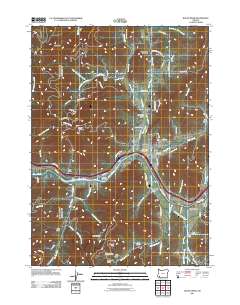
2011 Map of Rogue River
USGS Topo · Published 2011About this map
The Rogue River carves a deep path through southern Oregon in this 2011 survey, serving as the central artery for the surrounding valley and its tributaries. Near the confluence with Evans Creek, the town of Rogue River serves as a local hub, with the Rogue River Post Office and Woodville Cemetery situated just north of the water. The landscape is defined by a dense network of gulches and ridges, including the ominously named Starvation Heights and the prominent Fielder Mountain. Along the river's southern bank, the Gold Hill Irrigation District Canal traces the contour of the land, illustrating the vital role of water management in this terrain. Further east, the small settlement of Foots Creek is documented alongside the Foots Cemetery, providing specific data points for genealogists tracking local families near Millers Gulch and Gold Gulch. The map also captures numerous named landmarks like Seaman Bar and Big Bald Spot, reflecting a naming tradition rooted in the region's topographical character.
Find a feature on this map
87 named features on this map. Tap any name to fly to it.
Don’t see what you’re looking for? This feature index may not catch every label — zoom into the map to look around manually.
Map Details
Editions of this 2011 Rogue River Map
This is the sole edition of this map. No revisions or reprints were ever made.
Other maps of this area

1904 · Riddle
USGS Topo · 1:125,000

1908 · Grants Pass
USGS Topo · 1:125,000

1954 · Glendale
USGS Topo · 1:62,500

1954 · Gold Hill
USGS Topo · 1:62,500

1954 · Wimer
USGS Topo · 1:62,500

1954 · Grants Pass
USGS Topo · 1:62,500

1955 · Medford
USGS Topo · 1:250,000

1957 · Medford
USGS Topo · 1:250,000

1958 · Medford
USGS Topo · 1:250,000
1974 · Grants Pass NE
USGS Topo · 1:24,000